Iranaimadu spill water submerges Paranthan villages
[TamilNet, Tuesday, 14 December 2004, 10:58 GMT]
Torrential rain across Vanni district the last three days has filled the
Iranaimadu tank to levels close to the maximum 34 feet forcing the
spillway administrators to open the sluice gates at 32 feet water level,
sources in Vanni said. Villages in 14 Grama Sevaka divisions are badly affected
and villages north of Murasumoddai-Paranthan road
in Kandavalai AGA division are submerged in flood waters, sources added.
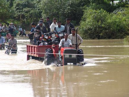 Road between Kilinochchi and Vaddakachchi
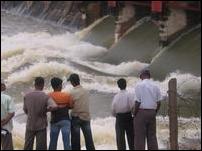 |
| Iranaimadu Tank |
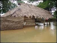 |
| House in floods |
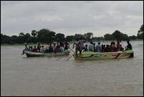 |
| Paranthan - Mullai Road |
Thattuvankottai, Umayalpuram, Uriyan, and Elephant pass have been
already submerged forcing the A9 highway unusable. Kunchuparanthan
salt production has been suspended and Kandavalai paddy fields have
been filled with flood waters, sources said.
Roads to Vattakatchchi, an interior village 5km east of Kilinochchi
town, has been cutoff from from Iranaimadu spill waters overflowing the
gravel road between Kilinochchi and Vattakatchi. Officials said they expect the rain to recede Tuesday night allowing
the travel situation to improve Wednesday.
Iranaimadu tank was formed joing two preexisting tanks in 1956 and holds
106,560 Acre.ft of water. The tank provides irrigation water to roughly
21700 acres of paddy fields, the tank's water passing through eight minor tank before joining the
elephant pass lagoon as Kanagarayan aaru.
Iranaimadu tank receives its water from Kanagarayan kulam via Kanagarayan
aaru, and from runoff and underground water from
a chain of following the tanks: Ilamaruthankulam, Semamadu tank, Arumugathan
Puthukulam, Omanthai Kulam, Paakusorinchan Kulam, Vilathikulam, Pandikeitha Kulam,
Palayavadi, Katchkodi, Sinna Adampan, Periya Adampan, Sadaiyankulam and
Karapukuthi.
Although the Mahaveli scheme diverted the river from joining Ilamaruthankulam, the seepage and underground passages still feed water to Ilamarunthankulam from Mahaveli ganga.